
Purgatory Chasm - Sutton, MA 01590

198 Purgatory Rd. Sutton MA 01590
Capron Park - Attleboro, MA 02703

201 County Street. Attleboro, MA 02703
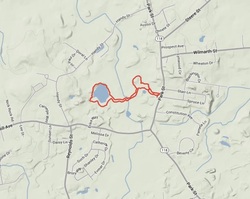
Stillwater Scenic Trail - Smithfield, RI 02917

The Stillwater Scenic Walkway is a short trail that follows an old railroad bed between Capron Road and State Route 104 (Farnum Pike) south of Smithfield. The trail passes through a wooded area along the shore of Stillwater Pond and Capron Pond. The trail provides access to Stillwater Reservoir.
Blackpoint Fishing Area/Wildlife - Narragansett, RI 02882

Route 1A R.I. Follow Ocean Road south. There is a free parking lot marked with a brown State of R.I. sign.
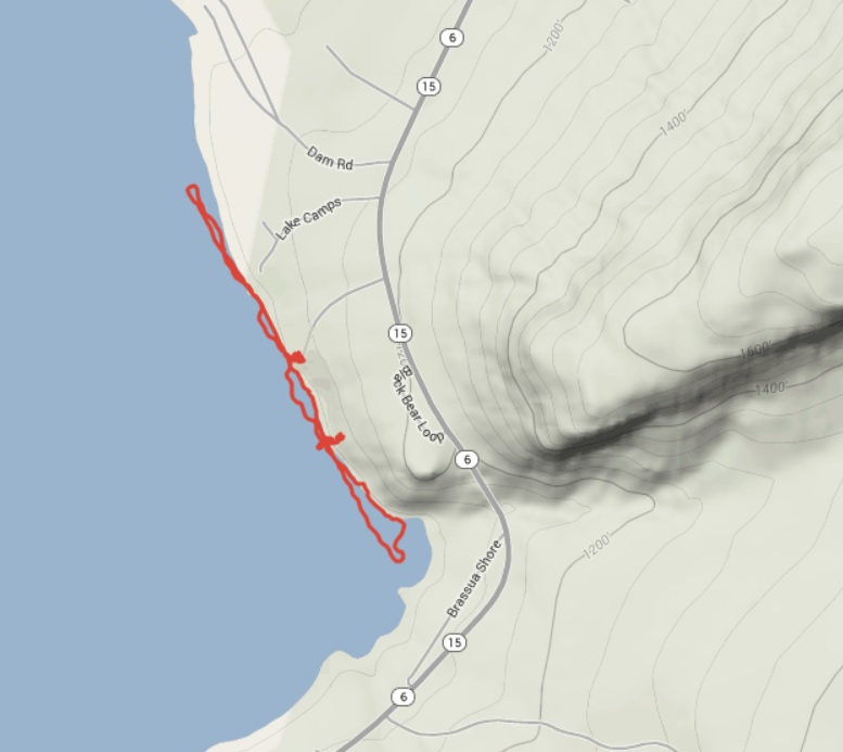
Mt. Kineo & Brassua Lake - Rockwood, ME 04478

|
I wish I could provide you with great directions to Mt. Kineo. However, there really are none. The best I can say is if you are in the Rockwood, ME area follow Jackman Rd. to the local dock area. From there you can take a ferry ride for $10 to bring you over to Mt. Kineo.
|
Trout Pond - Wrentham, MA 02093
Trout Pond is located minutes from the Wrentham Premium Outlets. There are 2 ways to enter. There is hidden road off of Beach St. or your can go onto Taunton St. The "landmark" in the area would be the Wrentham Senior Center. You will a road to the side of the center heading towards the woods. Follow the one that says "Building Inspections", this will lead you to Trout Pond. If you have a GPA type in 411 Taunton St Wrentham. MA and head across the street.
Caratunk Wildlife Refuge Seekonk, MA 02771
From I-195, take the Broadway exit. Bear left at the bottom of the ramp, onto Warren avenue, turn left at the first set of lights, onto Route 114 north. Travel approximately 2 miles and then turn right onto Route 152 north. Continue on Route 152 across a reservoir and into Seekonk. After you pass the middle school on the left, turn right onto Brown Avenue. Caratunk is 7/10 of a mile on the right. If you have a GPS all you need to do is type in 301 Brown Ave, Seekonk, MA.
Blackstone Gorge Blackstone, MA 01504
The entrance to the Blackstone Gorge and the Rolling Dam is at the end of County St in Blackstone, MA 01504. If you are coming from Woonsocket, RI 02895 follow Harris Ave onto Main St in Blackstone. Continue going straight past Blackstone St for a few miles. There will be signs pointing the way to the Gorge. Eventually, bare left and follow County Street. There is a small parking lot on the left.
Attleboro Springs Attleboro, MA 02703
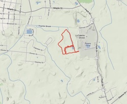
Take Rt I-95 to exit 5 (Rt 152). Turn left off the exit ramp and take a right onto Rt 152 south. After 1 mile, turn left onto Holden St. Take the first right onto Bank St. At the traffic light, turn left onto Park Street. Follow Park Street for 2.6 miles, road will curve right. Pass the LaSalette Shrine and turn down the road right after their main parking lot. The entrance is all the way down the road. If you have a GPS you can type in Attleboro Springs Rd Attleboro, MA 02703.
Powder Mill Ledges Greenville (Smithfield), RI 02917
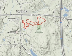
From I-295, take exit 7B onto Route 44 West. At fourth set of lights, turn left onto Route 5 (Sanderson road). Turn left at the second driveway into the parking lot. If you have a GPS simply put 12 Sanderson Rd Smithfield, RI 02917 and follow it right into the parking lot.
Oak Knoll Wildlife Sanctuary Attleboro, MA 02703
Take Rt I-95 to exit 5 (Rt 152). Turn left off the exit ramp and take a right onto Rt 152 south. After 1 mile, turn left onto Holden St. Take the first right onto Bank St. At the traffic light, turn left onto Park Street. Follow Park Street for 2.6 miles, road will curve right. Pass the LaSalette Shrine and Handy Street on the right. The sanctuary is located on the right side. Look for a white colonial house and Mass Audubon signs. If you have a GPS the address is 1417 Park Street Attleboro, MA 02703
Joe's Rock/Birchwold Farm Wrentham, MA 02093

Joe's Rock is roughly 1 mile over the Cumberland, RI border in Wrentham, MA. From RT 295 (north or south) take exit 11 on to RT 114 (Diamond Hill Road) north. Follow that for a roughly five miles until the road splits and take a right on RT 121 (Wrentham Road) the road eventually turns into West St. There will be a sign on the right for Birchwold Farm and a few feet down there will be a small parking area for Joe's Rock on the left.

Diamond Hill State Park/ Ski Valley Cumberland, RI 02864
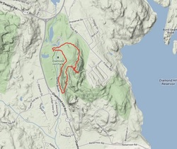
Diamond Hill offers spectacular views and a fairly gradual climb for young and older kids to enjoy. It’s also a great place to picnic and little ones will love checking out the small pond near the old band shell.The trails are not marked, and we’ve yet to find a map so pay extra attention along the way. Follow the paved path from the parking lot; it will lead you to a wooded path that comes right up against Fisher Road. Continue on the path to get to the summit (easily identified by the old ski lift footings). Return the same way, or take one of several paths to extend your hike.
From Route 295 North, take exit 11 for Route 114 North. At the end of the exit ramp, make a left and follow Rte. 114N about 4 miles. The park will be on your right just across from The Ice Cream Machine.
From Route 295 North, take exit 11 for Route 114 North. At the end of the exit ramp, make a left and follow Rte. 114N about 4 miles. The park will be on your right just across from The Ice Cream Machine.
Cumberland Monastery - Hayden Library 1464 Diamond Hill Rd. Cumberland, RI 02864

From Providence: take Rt. 146 North to Rte. 295. Take Route 295 North to exit 11 (Route 114, Diamond Hill Rd.). Turn right onto Diamond Hill Rd. and drive about one mile south. On your right, you will see a big red and blue sign that reads "The Monastery". This marks the entrance to the Monastery grounds where the library is located. Turn right at Monastery Drive and follow it into the parking lot. The library is set far back from the main road.
From the South: take Rte. 95 North to Rte. 295. Follow same directions as above.
From the North: take Rte. 95 South to Rte. 295. Take Rte. 295 South to exit 11 (Rte. 114, Diamond Hill Road). Turn left onto Diamond Hill Road and drive about one mile south. On your right, you will see a big red and blue sign that reads "The Monastery". This marks the entrance to the Monastery grounds where the library is located. Turn right at Monastery Drive and follow it into the parking lot. The library is set back from the main road.
Lime Rock Nature Preserve - Wilbur Rd. Lincoln, RI 02865

From Providence, take Route 146 to the Lincoln Woods exit (Twin River Road)Turn right at the end of the rampAt the first light, turn right onto Route 246 (Louisquisset Pike). Take 246 north to Wilbur Road (about 2.4 miles). Turn left onto Wilbur Road. Roughly .5 miles on the right will be the entrance to the Lime Rock Preserve – a small pull-off from the road. If using a GPS use the address 61 Wilbur Rd. Lincoln, RI. The small 2-3 car parking area is located diagonally from this location.
